I have been dreaming about running the Zion Traverse since I first learned of the route reading Matt Hart's
blog. It seems like every spring when I am reaching my limit with the clouds and rain in Seattle, I read about a Seattle runner making their way to Zion for a little spring break in the sun. I was very lucky to find two Seattle running friends, Brian and Bruce, to join me on the adventure this year. It was finally my turn to have a Spring Break in Zion and it absolutely did not disappoint. There is something about the combination of the shapes and colors of the rocks and the myriad canyons and mesas that just can't be beat. So if you have ever considered running in Zion, don't put it off. I'm hoping I can make this an annual rite of spring.
Andrew Skurka has written pretty comprehensively on the logistics of doing the traverse including an incredibly helpful
spreadsheet of water sources and trail junctions along the route. The only suggestion I would add on logistics is that we hired an outfitter,
Zion Adventures, to meet us at the western side (Lee Pass), where we left our rental car, and take us to Springdale where we spent the night in a motel. The next morning Zion Adventures picked us up at the hotel and dropped us off at the Eastern Rim trailhead so that we could run back to the car. The cost was reasonable and the service was excellent. This option seemed a little easier than renting a second car although either option would have worked fine. It did occur to me afterwards that if one wanted to conveniently run most of the route solo, it would be easy to hire the outfitter to take you from Springdale to Lee Pass and then you could run to the Grotto and take the free Zion shuttle back to Springdale. That route would encompass about 37 miles of the 48 mile traverse.
If you are looking for more information and inspiration on the Zion Traverse, here are a variety of blog posts people have written about their experiences:
Jason Henrie 2010,
Jason Henrie 2011,
Candice Burt,
Ted Mahon,
Dax Ross.
 |
| Google earth route map |
 |
| Elevation profile recorded on my Ambit. |
East Rim Trailhead to Echo Canyon Trailhead (10.4 miles)
The forecast was for a beautiful, although hot day. The shuttle dropped us off at the East Rim Trailhead right at 6am and a nearly full moon was already providing a little light although we started with headlamps on for the first half hour or so. By the time the sun came up we were looking down into the first of many beautiful canyons. Coming from sea level, we all noticed the effects of the ~6000 feet of altitude immediately. Halfway through this section we came to the Stave Spring and were surprised to find little to no water. It wasn't an issue for us given the cool morning temperatures, but for people running the route in the reverse direction it could be a disaster and it certainly made us nervous about the springs we were counting on later in the afternoon.
 |
| The rising sun lights up the moon over the East Rim Trail. Photo by Brian Maher |
 |
| Bruce running in Echo Canyon. Photo by Brian Maher |
 |
| Switchbacks coming down from Echo canyon into Zion canyon. |
Grotto Trailhead to Western Rim (Miles 11.6 to 16.3)
After a quick mile down the road to the Grotto trailhead, we filled up with water at the spigot outside the bathroom, crossed a footbridge over the Virgin River and started the biggest climb of the day. We knew there would be a lot of people on the climb until we passed the turnoff for Angel's Landing, but this section did not take long and there were few hikers after the turnoff. The views coming up to the top of the western rim were the most spectacular of the route. We made a quick water stop at the West Rim Spring and continued along the West Rim Trail.
 |
| Switchbacks just below Angel's Landing. Photo by Brian Maher |
 |
| Angel's Landing. Photo by Brian Maher |
 |
| The walls of upper Zion Canyon |
 |
| Looking back down on the trail through the upper part of Zion Canyon. |
Western Rim to Lava Point/Wildcat Canyon (Miles 16.3 to 25.8)
This section is one of the nicest sections to run. The trail goes along the mesa next to the canyon rim and the views into the canyon continued for much longer than I expected. The trail is very runnable with moderate up and down sections and a fair bit of shade. The temperature had reached about 75 degrees by this point in the day. We stopped for water at the Potato Hollow spring at mile 21 which you reach by turning on the trail towards campsite #8.
 |
| Typical view along the top of the mesa along the western rim. |
 |
| View into the canyon from the western rim |
 |
| View into the canyon from the western rim |
 |
| Me running on the western rim trail. Photo by Brian Maher |
Wildcat Canyon and Connector Trail (Miles 25.8 to 35.3)
We had decided to run the traverse from east to west in order to get the biggest climb of the day over early on fresh legs before it got too hot. Starting around mile 27, we got to reap the reward for this choice since the route goes predominantly downhill for the next 15 miles. The temperature was now in the 80s so the easier downhill trail was appreciated. I nearly stepped on snakes on two different occasions in this section and was happy that the snakes did not react to me jumping over them. I don't think they were rattlesnakes but I really didn't want an encounter with any kind of snake.
 |
| Descending into Wildcat Canyon |
 |
| Firepit knoll where the connector trail crosses Kolob Terrace road |
Hop Valley (Miles 35.3 to 41.7)
Hop valley is an amazing section of the trail due to the variety of terrain and scenery. Unfortunately, the temperature was pushing 90, the trail is mostly sand, and this section completely kicked my butt. I have to confess that I was desperate for it to end so that we could start the final section of trail. Hop valley starts as a relatively flat mesa with views to the walls of Kolob canyon along the final section of trail still miles away. After a couple miles of mesa, the trail drops steeply down into a canyon and then meanders along a creek which seems like it will never end.
 |
| Bruce running through the sand at the beginning of Hop Valley. Photo by Brian Maher |
 |
| Looking down into Hop Valley |
 |
| The never ending section along the creek bed. Photo by Brian Maher |
 |
| First view of Kolob canyon from the end of Hop Valley |
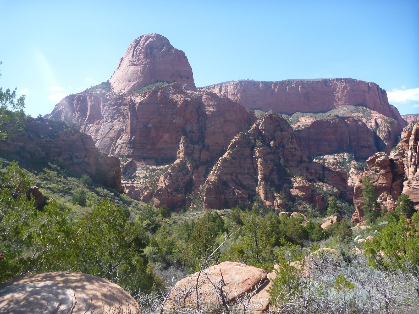
Kolob Canyon (Miles 41.7 to 48.3)
The longest section of our route without a spring was from roughly mile 31 to mile 42. Since the trail crosses a road (Kolob Terrace) at the beginning of Hop Valley, we could have arranged a water drop there to reduce the distance between springs. It all worked fine without the water drop, but I was completely out of water for the last couple of miles in Hop Valley and was stoked to reach the pretty La Verkin creek at the beginning of Kolob Canyon. Purifying water and refueling should have been paradise, but the area was just plagued by biting horse flies that left my legs covered with welts. By the time we had re-grouped at the creek, re-filled with water and taken stock of the damage the heat had done to us, we decided to hike the last 6 miles out to the car. I can't wait to return for another Spring break in Zion.
 |
| La Verkin creek in Kolob Canyon. Photo by Brian Maher |
 |
| Looking back into Kolob canyon. |
 |
| Brian at the finishing trailhead at Lee Pass. |

