Tuesday, December 10, 2013

Abel Tasman Running

Our New Zealand adventure started with an amazing trail run on the Abel Tasman track through the Abel Tasman National Park. I highly recommend visiting this park if you are on the south island. The trail is very well maintained and the views are stunning. The trail is very accessible since there are numerous water taxi services that will take you by boat to whatever beach you want to start at. You can run the trail back to Marahau, or schedule a boat pickup if you only want to run a section. If you wanted to be completely self-powered, you could kayak out to one of the beaches and have the water taxi pick return the kayak while you run back to Marahau. The map below shows you the trail with some of the water taxi stops. If you don't want to run the trail on your own, there is also a race on the trail in September. Our guide book had suggested that the trail might be overrun by hordes of tourists. There were a fair number of people, but they were well spread out over the ~50 km of trail and most of the beaches seemed empty. I started at Onetahuti and ran back to Marahua which was about 16 miles and 2,000 feet of climbing according to my Ambit.

Map of the park
Starting at the Onetahuti beach

Suspension bridge

Trail alternates between beaches and coastal hills

Well maintained trails are highly runnable

I can't get enough of the views

Islands and never ending beaches

Following the orange signs across the beach. Sections such as this are impassable at high tide (there is an inland alternative).

Kaiteri with Abel Tasman behind on a perfect day.


Wednesday, October 2, 2013

Mountain Lakes 100

Last weekend I participated in the inaugural Mountain Lakes 100, er 71 miler. The National Weather service issued a special weather advisory on Thursday warning of possible record rainfall from Friday through Sunday with almost continuous rain accompanied by heavy winds. They were not wrong. It didn't sound like the nicest way to run 100 miles, but my fundamental stubbornness (thanks Mom) didn't let me seriously consider not starting.

Somewhere in the first loop. Photo by Michael Lebowitz, Long Run Picture Company
It rained almost all of the time with occasional high winds, particularly in a few sections where the trail wasn't sheltered by trees. Astounding amounts of water either pooled on or ran over the trails keeping the lower half of your body well soaked and chilly most of the time. The PCT was generally an exception to this which I interpreted to mean that the construction and maintenance of the PCT was done to a much higher standard to minimize erosion to the trail. Running through so much water was definitely hazardous since you couldn't see potential obstacles under the water but I was fortunate to only fall once. This race video gives a good feeling for the conditions.


Despite the poor conditions, I had a really good day of running. I stayed on top of my nutrition mixing in a significant amount of real food for the first time. I had recently purchased Feed Zone Portables, and made rice souffles, basically scrambled eggs mixed with rice which went down really easily and were more satisfying than constant gels, although I ate plenty of those as well. I really didn't have any major low points and did a much better job of staying in the moment, focused on taking care of myself and running as well as I felt. I did not spend really any time calculating how much time or mileage was left and this made the day much easier mentally. Unfortunately, when I reached the Clackamas aid station for the second time at mile 71, I was told the Race Directors had decided to cancel the race due to the poor weather and concern that runners were having trouble staying warm as the temperature dropped during the night. I was very fortunate to get a ride with another runner's pacer (Thanks Kirby!) almost immediately. By the time we got back to the starting line an hour and a half later, the rain was turning to snow and my car had an inch or two of snow on it. This is the second time that I have been in a hundred mile race that got canceled and it pretty much establishes me as the hundred miler weather jinx. You might want to be sure that I am not signed up for any races that you are contemplating next year.

The portion of the course that I ran. The remainder of the course was to finish the out and back down from the red loop at the top back to the arrow by the green loop at the bottom.
For readers who might be curious about the course and whether they should enter this race in 2014, I will attempt to describe the course and scenery although there is a big caveat that the bad weather limited our views and may have negatively prejudiced my impression of the scenery. The course is a double out and back, or more properly a double lollipop since each out and back ends with a loop. The course sits between Mt. Jefferson to the south and Mt. Hood to the north, neither of which we ever saw but I am assuming on a clear day there would be some good views of one or both mountains. Approximately 60 miles of the course is run on the PCT which was highly runnable sweet single track with modest grades and minimal technical sections. The two loops at either end had more technical sections, but not bad. The first loop had a lot of dirt road, but it also had one of my favorite sections of the race, trail 719. This trail was more technical with some climbing but it passes by a bunch of nice lakes. The second loop is relatively flat as it goes around Timothy Lake which I got a few brief glimpses of before darkness set in. Overall, it was the most runnable 100 mile course that I have done (despite not finishing the race, I did run all of the trails that the course covered). The PCT generally stayed well under the trees with only a few spots with the potential for broad views. The course does not really climb any mountains per se, although there is about 12,000 feet of climbing (if we had been able to finish the entire course) according to my Suunto.

Elevation profile
This was a first year event and for the most part the logistics worked okay and the course was marked reasonably well. The distances and elevation profile posted on the web site seemed accurate, or at least consistent with what my Suunto recorded. There were some great volunteers working at the aid stations and I suspect that they suffered from the weather conditions more than the runners did. However, there were a number of issues that the race directors could improve upon next year.

1) Consistent trail marking--most of the turns were marked extremely well with big white signs. But that made the turns which were more casually marked much easier to miss. A bunch of us missed the turn onto trail 719. My one serious complaint about the race was an almost complete lack of trail markings between Timothy Lake Dam and Clackamas. I can only imagine that the person marking ran out of markers, but I am not sure why that could not have been fixed or at least why we weren't warned. The trail markings that were used in this section did not have any reflectors so they were extremely difficult to find in the dark. I guess it is possible someone vandalized the markings, but the section affected lasted several miles. At one trail intersection, there were no markings on either possible trail for a half a mile or more resulting in the following trace on my GPS recording:

Portrait of an unmarked turn
2) Chairs at aid stations--I know people warn to beware the chair, but when I get to an aid station with a drop bag, I want to sit down briefly while I get the stuff I need out of the bag, change socks, etc. Given the weather, I really want to do this in a dry place. Inexplicably to me, the largest aid station (Clackamas), did not have a good dry space with chairs to do this.

3) Better course description on the website--the website had really nice maps and elevation profiles, but no details on what trails the course would take beyond the PCT. At the two turns where I got lost, having a written table listing the specific trails/turns we would take would have solved the problem very quickly. I took the printed out maps with me, but they were no help.

Overall, I would recommend this race to people who are checking it out and I think it has the potential to be a really outstanding event. I am disappointed that we did not get to finish, but I still had a positive experience and would consider running the event again one day.


Sunday, September 8, 2013

Copper Ridge Loop

This summer I have consistently managed to get into the backcountry for some stellar running adventures. The Copper Ridge Loop in the north cascades is definitely one of the summer highlights, in part due to the sockeye salmon we saw spawning in the Chiliwack River. It's one thing to see this on a nature show, but it was awesome to see it in person. There were so many fish you could practically walk across the river on them (although in reality they quickly swam away when we started fording the river).

Salmon spawning in the Chilliwack River.
To start at the beginning, we met in Mt. Vernon at 5am and arrived at the Hannegan Pass trailhead east of Bellingham and north of Mt. Baker around 7:30am. The route starts with a 4 mile uphill climb to Hannegan Pass and then shortly afterwards the trail divides. We opted to continue uphill on the Copper Ridge trail and then return via the Chilliwack River Trail. The approximate distance of the loop is 34 miles with about 9,000 feet of climbing. The views from the higher elevations on the Copper Ridge were magnificent, although we did not have a clear day and I will definitely need to run this loop again (or even an out back to the lookout) on a clear day. There was good availability for water and I only carried two bottles, although once you get onto Copper Ridge there was a 5-6 mile section without water until we got to Copper Lake. We refilled with water just past the lake where an outlet stream crosses the trail, and then again at the bottom of the long downhill shortly before the junction with the Chilliwack River trail. If one really needed water along Copper Ridge, there were a couple of lakes at campgrounds that were available although you would have to go a mile or so out of the way to get the water.


Elevation Profile

Scotty, myself and Rich at the trail head

In the valley leading up to Hannegan Pass

Looking back at Hannegan Pass

Views from Copper Ridge

The ranger's lookout at the high point on the ridge

Scotty descending

Copper Lake

I don't know what valley this is, but I want to explore it sometime

Looking north into Canada with a glimpse of Chillwack lake on the right

Chilliwack river, upstream of the salmon spawning

View down the valley towards the trailhead

Moon over Hannegan pass


Garibaldi Lake

I spent the past few days in Vancouver and decided to take advantage of a free day to do a backcountry run. I got the idea from the course for the Rubble Creek Classic race which is held at the end of September and looks like a very cool event. The race is an approximately 24 km point to point run from Cheakamus Lake to Garibaldi Lake. Since I needed a longer workout and didn't have a car shuttle, I decided to start at the trailhead for Garibaldi Lake and do an out and back run. The trails were incredibly well marked and although I had printed out a map from the park website, I never looked at it during the run. Water was plentiful and I took 2 water bottles which I refilled at a stream a little past the halfway point of my run. I did not make it quite all the way to the trailhead at Cheakamus Lake. If I were to do a similar run in the future, I would turn around at Helm Creek Campground before descending down into the trees towards Cheakamus Lake, and add on the trail to the top of Panorama Ridge. Another option is to climb Black Tusk, but it sounds too technical for me. There is pretty incredible scenery in the middle of the route once you have climbed above treeline. The views were somewhat limited by swirling clouds and fog but I will let the pictures tell the rest of the story.

Route map-I stopped a mile or two short of the entire route used in the race.

The route starts off with a long and fairly intense climb.

Helm Lake

Crossing a field of volcanic rock

Helm Creek meadow

Stream crossing beneath the Cinder Cone

Black Tusk appears briefly when the clouds clear

Panorama Ridge

Garibaldi Lake

Wednesday, September 4, 2013

Devil's Dome Loop

Jen, Bruce and myself ready to start the run.
Last weekend I went with Jen and Bruce to run the Devil's Dome Loop in the Northern Cascades. This is the second time that I had run the loop and it was fun to return to such a beautiful area on a day with different weather, at a different time of year, etc. You can read Scotty's blog post on our previous trip here. I'm not going to write a narrative of our day in this blog post, but I did want to share some logistical data, particularly information on places where water was available. The guide book I have with a writeup of the route cautions that water can be scarce. The previous time I ran the loop we ran it in early August and water and snow were plentiful. Considering that it was a month later that we were running the loop this year I was concerned that many of the water sources we used the previous trip might be dried up. We all ended up carrying big loads of water that it turns out we didn't need. We started at the East Bank trailhead on Highway 20 and did the loop counterclockwise which as you can see in the elevation profile below puts most of the climbing at the beginning of the day. Next time I will have to run the loop clockwise and see how much harder it is with the climbing at the end of the day.

Route map starting at the East Bank Trailhead and running counter clockwise

Elevation profile
The following list shows the approximate mileage based on my GPS watch recording to water sources all of which seemed fairly reliable although clearly if you go late enough in the year some of these could be dried up. I am confident that the loop can be done with a couple of bottles instead of a hydration pack, but if you do want to take a hydration pack, wait until mile 6 or 7.8 and then fill it up once you have done a lot of the initial climbing.

Distance Name Note
4.5 miles Unknown stream About 3000 feet elevation
6 miles Unknown stream ~5,000 feet near top of initial climb
7.8 miles Nickol Creek McMillan Park
14.6 miles Middle Fork Devil's Creek
15.1 miles North Fork Devil's Creek
17.5 miles Spring near Devil's Pass We didn't use this since it requires a slight detour off the route onto trail 752 (turn right instead of left at the pass)
22 miles Snowmelt just past Devil's Dome on the way down Presumably dries up late in the season but good amount of water now with snow still on the ridge above
25 miles Unknown stream
25.5 miles Unknown stream
32.6 miles May Creek First place to get water after dropping down to the lake (5 miles after turning onto East Bank trail)
37 miles Unknown stream Several stream crossings in the last few miles

A few pictures from the run:

McMillan Park meadow


Lots of beautiful ridge running
Bruce and Jen descending the scree field

More ridge running

Looking at Devil's Dome (highest peak) and north from the saddle below

The route circumnavigates Jack Mt. This is the view from Devil's Dome.

Friday, June 21, 2013

Humble Pie

This post is a recount of my first DNF which occurred at the San Diego 100 a couple of weeks ago. It is ironic that I had prepared more for this 100 miler than for any of the previous 100 milers that I had completed. This year my goal was to break 24 hours in a 100 mile race and to help me achieve this goal I hired a coach and trained more than ever. I was and am still confident that I started the race in the best shape of my life. What happened? In a word heat. I had hesitated to choose San Diego as my 100 mile race for this summer since historically I have not fared well in hot conditions. When we ran the Zion Traverse in April, afternoon temperatures reached the 90s and although I did OK during this run, it was a wake up call that I needed heat training to prepare for San Diego. For the next 6 weeks leading into the race, I did 2-3 sauna sessions a week at 170 degrees starting for 15 minutes and building up to 40 minute sessions. I also did 1 or 2 runs a week overdressed in several extra layers of clothing. In May, I went down to San Diego to pre-run sections of the course with my friends BJ and Gonzo who do most of the course marking for the event. I held up well to the 90 degree temperatures we experienced out on the course that weekend, so I was optimistic going into the race that I had achieved some measure of heat acclimatization.

I have already blamed the heat for my DNF, but Jimmy Dean Freeman has argued on his blog that heat didn't cause runners to drop. He argues that runners dropped because they failed to properly adjust for the hot conditions. I will review the issues that I had during the race and the adjustments that I attempted to make in the hopes that other runners preparing for hot race conditions may learn something from my experience.

Pacing: I started the race wearing my heart rate monitor to help make sure that I didn't get carried away and run too fast. The goal was to keep the heart rate between 140 and 150 with an upper limit of 160. Since hot conditions will cause the heart to beat faster to push blood to the skin to help with cooling, monitoring heart rate helped me maintain an appropriately easy pace even in the hot conditions. My pre-race plan was to take the monitor off at the first drop bag (mile 23) and I stuck to that plan. My average heart rate for that section of the course was 152, so a little bit high, but I am confident that my issues were not primarily caused by starting the race at too fast a pace.

Hydration: I started with two bottles of fluid, one filled with water and one with Ultrafuel (300 calories/16 oz). My plan was to drink at least 1 bottle per hour and I think I averaged about 1.5 bottles per hour. At the first drop bag I picked up a 3rd bottle which I had originally planned not to fill until the big uphill at mile 36, but given the conditions I filled the bottle at mile 23 which was good because I had finished all 3 bottles when I reached the next aid at mile 30. I don't think dehydration played a significant role in my downfall since I was not thirsty when I eventually dropped out, nor did I drink more than usual the evening after dropping out.

Nutrition: My primary fueling plan was to get calories from the Ultrafuel (mixture of maltodextrin and simple sugars) dissolved in water. I had gels and chews as backup. It did not take long for calories to become an issue. The first bottle of Ultrafuel went down easily, but about halfway through the 2nd bottle, my body just rejected it. I probably should have taken this more seriously. At the time I decided to drink only water for 45 minutes in the hopes that with the extra time my stomach would begin processing some of its contents. I then tried a gel which went down fine, but about 5 minutes later my stomach begin hurting so badly I switched to walking for about 10 minutes until the pain subsided somewhat. I never managed to solve the stomach shutdown.

Electrolytes: This may make me a heretic, but I do not normally take salt pills during ultras. The first two times someone talked me into trying them, I immediately felt sick. I have used Nuun occasionally and I had some Nuun with me just in case. About mile 27 when I first started struggling to continue, I tried a bottle of Nuun, but it did not help.

Staying cool: I learned from my friend Bruce a couple of years ago during our first Wonderland Trail attempt to use a bandanna filled with snow or ice or dipped into cold water and then tied around your neck to cool off. I started using a cold bandanna at mile 23 and also put ice in my hat. I think my biggest problem was an elevated core temperature that prevented my stomach from absorbing calories. The one thing I would definitely do differently if I were back in the race was around mile 27 when the noble canyon trail crosses a cool stream. I stopped here and wet down my hat and bandanna a couple of times and rested in the shade trying to get my body temperature down. In retrospect, I can't believe that I didn't just sit or lie in the stream which would have been far more effective at lowering my core temperature and might have brought me back to life.

As it was, I walked from that stream crossing 2 miles downhill to the Pine Creek Aid Station at mile 30 intending to drop. It's funny that now I can't explain or remember why I felt so bad that I would have dropped, but that was definitely my intention. I sat at the aid station packed in ice for 45 minutes until I managed to get down 3-4 small cups of coke and a few pringles. The volunteers at this aid station were the best! When I returned to this aid station after a 5 mile loop, the aid station had turned into a hospital with runners laid out all over the place. I started up the biggest climb of the course, about 2500 feet over the next 7 miles. I was not up to power hiking, but walked at a steady pace except for when I drifted too close to a tree along the right side of the road and was enveloped in a cloud of angry wasps. I was amazed that I only got stung once. About 2/3 of the way up this climb after the route turns right off the road onto some nice single track, I started hyperventilating. I remember thinking that my body had decided panting was the only way to cool down. I was desperate for some shade but this is one of the more exposed sections of the course. Finally a small shrub offered some shade and I crouched down in the shade next to the trail. I don't really remember what happened next very well, but some other runners stopped to check on me. I could hear them, but my field of vision had gone white and I could not see them and I struggled to communicate with them. I finally insisted that I would be OK and that they should continue. I have no idea how long I was there, but eventually my breathing slowed and I decided to try to stand up. I started walking extremely slowly towards the next aid only to find my calves cramping so badly that it was hard to walk. About 2 miles later I encountered a runner coming towards me. The aid station had sent Karl to check and make sure I was OK so we walked the last 2 miles together to the aid station at mile 44. Karl went on to meet his runner at the mile 51 aid station to pace and I dropped.

I did not make any attempt to regroup at the aid station at mile 44. The temperature had definitely cooled by this point and it is certainly possible that if I had managed to get some food down at this aid station that I would have revived, but frankly I was too scared by my collapse on the trail to consider continuing. It is interesting to me to compare my reaction after this DNF to my experience at Coyote Two moon in 2011 when the race was canceled when I was at mile 83. After Coyote Two Moon, I was itching to start another 100 and get the finish experience. After San Diego, I was mainly scared. I never wanted to feel that way in a race again and I am not in any hurry to start another 100.

I did not complete enough of the course to provide any useful information for someone planning to run the race, but I found the following reports the most helpful in my preparations: Rick Gaston's writeups from 2012 and 2010 and Tim Long's writeups from 2012 and 2011.


Thursday, May 9, 2013

Spring Break on the Zion Traverse

I have been dreaming about running the Zion Traverse since I first learned of the route reading Matt Hart's blog. It seems like every spring when I am reaching my limit with the clouds and rain in Seattle, I read about a Seattle runner making their way to Zion for a little spring break in the sun. I was very lucky to find two Seattle running friends, Brian and Bruce, to join me on the adventure this year. It was finally my turn to have a Spring Break in Zion and it absolutely did not disappoint. There is something about the combination of the shapes and colors of the rocks and the myriad canyons and mesas that just can't be beat. So if you have ever considered running in Zion, don't put it off. I'm hoping I can make this an annual rite of spring.

Andrew Skurka has written pretty comprehensively on the logistics of doing the traverse including an incredibly helpful spreadsheet of water sources and trail junctions along the route. The only suggestion I would add on logistics is that we hired an outfitter, Zion Adventures, to meet us at the western side (Lee Pass), where we left our rental car, and take us to Springdale where we spent the night in a motel. The next morning Zion Adventures picked us up at the hotel and dropped us off at the Eastern Rim trailhead so that we could run back to the car. The cost was reasonable and the service was excellent. This option seemed a little easier than renting a second car although either option would have worked fine. It did occur to me afterwards that if one wanted to conveniently run most of the route solo, it would be easy to hire the outfitter to take you from Springdale to Lee Pass and then you could run to the Grotto and take the free Zion shuttle back to Springdale. That route would encompass about 37 miles of the 48 mile traverse.

If you are looking for more information and inspiration on the Zion Traverse, here are a variety of blog posts people have written about their experiences: Jason Henrie 2010, Jason Henrie 2011, Candice Burt, Ted Mahon, Dax Ross.

Google earth route map
Elevation profile recorded on my Ambit.
East Rim Trailhead to Echo Canyon Trailhead (10.4 miles)
The forecast was for a beautiful, although hot day. The shuttle dropped us off at the East Rim Trailhead right at 6am and a nearly full moon was already providing a little light although we started with headlamps on for the first half hour or so. By the time the sun came up we were looking down into the first of many beautiful canyons. Coming from sea level, we all noticed the effects of the ~6000 feet of altitude immediately. Halfway through this section we came to the Stave Spring and were surprised to find little to no water. It wasn't an issue for us given the cool morning temperatures, but for people running the route in the reverse direction it could be a disaster and it certainly made us nervous about the springs we were counting on later in the afternoon.

The rising sun lights up the moon over the East Rim Trail. Photo by Brian Maher
Bruce running in Echo Canyon. Photo by Brian Maher
Switchbacks coming down from Echo canyon into Zion canyon.


Grotto Trailhead to Western Rim (Miles 11.6 to 16.3)

After a quick mile down the road to the Grotto trailhead, we filled up with water at the spigot outside the bathroom, crossed a footbridge over the Virgin River and started the biggest climb of the day. We knew there would be a lot of people on the climb until we passed the turnoff for Angel's Landing, but this section did not take long and there were few hikers after the turnoff. The views coming up to the top of the western rim were the most spectacular of the route. We made a quick water stop at the West Rim Spring and continued along the West Rim Trail.

Switchbacks just below Angel's Landing. Photo by Brian Maher

Angel's Landing. Photo by Brian Maher
The walls of upper Zion Canyon

Looking back down on the trail through the upper part of Zion Canyon.


Western Rim to Lava Point/Wildcat Canyon (Miles 16.3 to 25.8)

This section is one of the nicest sections to run. The trail goes along the mesa next to the canyon rim and the views into the canyon continued for much longer than I expected. The trail is very runnable with moderate up and down sections and a fair bit of shade. The temperature had reached about 75 degrees by this point in the day. We stopped for water at the Potato Hollow spring at mile 21 which you reach by turning on the trail towards campsite #8.

Typical view along the top of the mesa along the western rim.

View into the canyon from the western rim

View into the canyon from the western rim

Me running on the western rim trail. Photo by Brian Maher
Wildcat Canyon and Connector Trail (Miles 25.8 to 35.3)

We had decided to run the traverse from east to west in order to get the biggest climb of the day over early on fresh legs before it got too hot. Starting around mile 27, we got to reap the reward for this choice since the route goes predominantly downhill for the next 15 miles. The temperature was now in the 80s so the easier downhill trail was appreciated. I nearly stepped on snakes on two different occasions in this section and was happy that the snakes did not react to me jumping over them. I don't think they were rattlesnakes but I really didn't want an encounter with any kind of snake.

Descending into Wildcat Canyon

Firepit knoll where the connector trail crosses Kolob Terrace road
Hop Valley (Miles 35.3 to 41.7)

Hop valley is an amazing section of the trail due to the variety of terrain and scenery. Unfortunately, the temperature was pushing 90, the trail is mostly sand, and this section completely kicked my butt. I have to confess that I was desperate for it to end so that we could start the final section of trail. Hop valley starts as a relatively flat mesa with views to the walls of Kolob canyon along the final section of trail still miles away. After a couple miles of mesa, the trail drops steeply down into a canyon and then meanders along a creek which seems like it will never end.

Bruce running through the sand at the beginning of Hop Valley. Photo by Brian Maher

Looking down into Hop Valley
The never ending section along the creek bed. Photo by Brian Maher
First view of Kolob canyon from the end of Hop Valley
Kolob Canyon (Miles 41.7 to 48.3)

The longest section of our route without a spring was from roughly mile 31 to mile 42. Since the trail crosses a road (Kolob Terrace) at the beginning of Hop Valley, we could have arranged a water drop there to reduce the distance between springs. It all worked fine without the water drop, but  I was completely out of water for the last couple of miles in Hop Valley and was stoked to reach the pretty La Verkin creek at the beginning of Kolob Canyon. Purifying water and refueling should have been paradise, but the area was just plagued by biting horse flies that left my legs covered with welts. By the time we had re-grouped at the creek, re-filled with water and taken stock of the damage the heat had done to us, we decided to hike the last 6 miles out to the car. I can't wait to return for another Spring break in Zion.

La Verkin creek in Kolob Canyon. Photo by Brian Maher
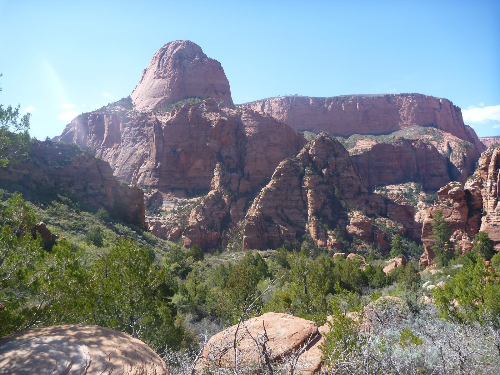
Looking back into Kolob canyon.
Brian at the finishing trailhead at Lee Pass.